Near Real Time Validation
Last validation statistics update:
Surface Chlorophyll and Kd490
MedBFM model simulation versus (minus) multi satellite observations (MODIS and Sentinel-3). Statistics of bias and root mean square difference (RMS) are computed daily for the first 3 days of forecast and compared with the Estimated Accuracy Number (EAN; QuiD) for:
- Chlorophyll
- Light attenuation coefficient at 490nm (Kd490)
BGC-Argo float: profiles
Last available biogeochemical-Argo and Argo floats (red), PPCon NN reconstructed profiles (orange, Pietropolli et al., 2023) and model forecasts (1st day of forecast, green) and analysis (after assimilation, blue) at the observations location and time. Availability of sensors can vary from float to float.
Observations for biomass of phytoplankton (PhytoC) and particulate organic carbon (POC) are retrieved from Bbp700 data using Bellacicco et al. (2019) relationship. Photosynthetic Active Radiation (PAR) is the 400-700nm downward radiation.
BGC-Argo float: skill metrics
Statistics of bias and root mean square difference (rmse) are computed weekly for the first day of forecast in selected large sub-basins and layers. Number of available floats in grey.
Time evolution of BGC-Argo float -
Hovmoller diagrams of chlorophyll concentration (mg/m3) from float data (2nd row) and model outputs (3rd row) matched-up with float position (1st row) in the previous 24 months. From 4th to 7th rows, computation of selected skill indexes for model (solid line) and float data (dots). The skill indexes are respectively: surface (SURF) and 0‑200 m vertically averaged (INTG) chlorophyll, correlation (CORR), depth of the deep chlorophyll maximum (DCM, blue) and depth of the mixed layer bloom in winter (WBL, red). Trajectory of the BGC‑Argo floats is reported in the upper panel, with deployment position (blue cross).
Hovmoller diagrams of nitrate concentration (mmol/m3) from float data (2nd row) and model outputs (3rd row) matched-up with float position (1st row) in the previous 24 months. From 4th to 7th rows, computation of selected skill indexes for model (solid line) and float data (dots). The skill indexes are respectively: nitrate concentration at surface (SURF) and 0‑350 m vertically averaged concentration (INTG), correlation between profiles (CORR), depth of the nitracline computed as NITRCL1 and NITRCL2. Trajectory of the BGC‑Argo floats is reported in the upper panel, with deployment position (blue cross).
NITRACL1 is defined as the depth at which the nitrate concentration is 2 mmol m-3; NITRACL2 is defined as the depth at which the depth derivative of the nitrate profile is maximum
Hovmoller diagrams of oxygen concentration from float data (2nd row) and model outputs (3rd row) matched-up with float position (1st row) in the previous 24 months. From 4th to 7th rows, computation of selected skill indexes for model (solid line) and float data (dots). The skill indexes are respectively: oxygen concentration at surface (SURF) and oxygen at saturation (O2sat), 0‑200 m vertically averaged concentration (INTG), correlation between profiles (CORR), depth of oxygen minimum zone (between 200‑1000 m, OMZ) and depth of maximum “surface” oxygen (between 0‑200 m, O2max). BGC‑Argo floats is reported in the upper panel, with deployment position (blue cross).
DA misfit satellite
Time series of: weekly misfit RMS with respect to satellite observations (top), weekly coverage observations (middle), daily number of available observations and of excluded ones (bottom).
DA misfit float
Time series of:
- daily misfit RMS with respect to float observations at two/three layers (top), daily percentage of used observations (middle), number of assimilated profiles and of excluded ones (bottom)
- daily misfit RMS/bias at different layers compared with QuID (CMEMS quality information document) estimated accuracy numbers (EAN; QuiD)
- monthly misfit RMS/bias at different layers compared with QuID (CMEMS quality information document) estimated accuracy numbers (EAN; QuiD)
Model Time Series
Time series of concentration at different depths (left panels) and mean vertical profiles (right panel) in the current season (grey areas in left panels) for the current year and the two previous ones
Last update:
ANALYSIS vs SAT
For each Mediterranean sub-basin[1]:
- averaged surface (0-10 m layer) Chlorophyll concentration of the weekly analysis runs in open sea areas (black solid line, MODEL) and the sub-basin spatial standard deviation (STD, dotted black line), compared with the DT/NRT multi-sensor satellite data (green dots, SAT) and corresponding sub-basin spatial STD (shaded green area);
- skill performance of the analysis quantified by the BIAS (MODEL-SAT; blue) and the Root Mean Square Difference (RMSD, black) between model and satellite data.
The timeseries are for a running-time window of the last 24 months. Units for Chl-a are in mg/m3.
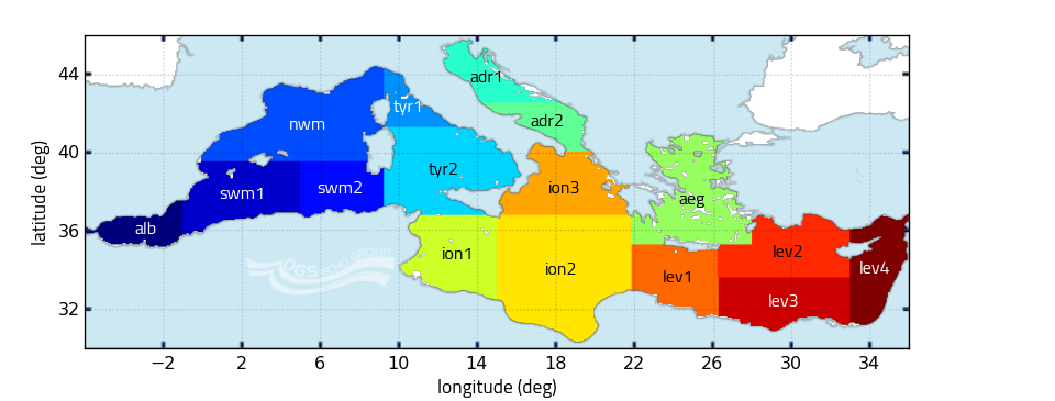
1.^Statistics are computed over the following subdivision of the Mediterranean Sea: (Salon et al., 2019)
The Near Real Time skill performance page aims at delivering sustained on-line information of the quality of biogeochemical forecast products (i.e. to identify main biases and suspicious trends in the time series, and to establish accuracy values for simulated variables). Validation task is performed using both independent and semi-independent data (i.e., data lately assimilated).
Statistics are computed over the following subdivision of the Mediterranean Sea

Additional detail about CMEMS validation activities at the following link
Near Real Time on line validation of physical variables at the following link
